Published:
The Falkland Islands are at risk from tsunamis caused by underwater landslides, according to new research.
Scientists from Heriot-Watt University and the British Geological Survey found evidence of prehistoric submarine landslides in the Falkland Trough.
The landslides are all in the same location and the scientists say the Subantarctic Front, a branch of one of Earth’s strongest currents, was behind the formation of the landslides.
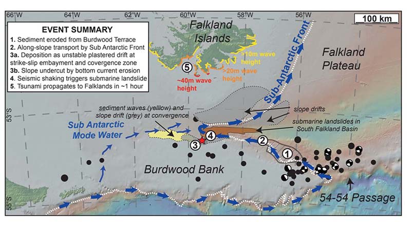
The landslides came from a drift that formed when strong currents, up to 50 million cubic metres of water per second, pushed sediment high up on the continental slope, at 400-1000 metres underwater. A tipping point would then occur and cause a landslide.
Sediment has been accumulating again at the site, named Burdwood Drift by the researchers, where the seabed is so steep it will collapse again - but they can’t tell when.
Most large tsunamis, such as the Indian Ocean event Boxing Day tsunami in 2004, or the 2011 event in Japan, were caused directly by large earthquakes.
However, landslides have also triggered tsunami waves, including the 1998 Papua New Guinea tsunami, the prehistoric Storegga landslide that inundated Scotland around 8000 years ago and most recently in 2018, on Sulawesi in Indonesia.
Dr Uisdean Nicholson, a sedimentary geologist at Heriot-Watt University, said: “We used seismic data to see the differences in the density of the offshore sediments.
“This allowed us to image the sedimentary bodies beautifully in three dimensions, similar to an ultrasound scan of the Earth.
“If you think about how the aftermath of a landslide looks on land, it’s the same underwater. Picture a huge volume of mud, sand and km-size blocks of rock cascading down onto the ocean floor.
“The large landslides shifted around 100 km3 of sediment - that’s enough to bury a city the size of Edinburgh under 400m of material.
“But we also found evidence of smaller landslides that generated tens of cubic kilometres of material and happened more frequently. These would still provide a real hazard.
“All of the landslides formed in one area along the Burdwood Bank, which is a fragment of continental crust that broke away from Patagonia around 30 million years ago, and was displaced along the active tectonic plate boundary.
“We’ve proved the critical role that the current played in the formation of these landslides: it erodes the seabed on the east side of the bank and then acts like a conveyor belt, transporting the sediment 200 km to the west and then dumping hundreds of cubic kilometres of mud, sand and silt on the slope of the bank.
“The material that it deposits is highly unstable, as it is on a steep slope, and the base of the drift is also eroded by the current, further steepening and destabilising the slope. Any weak layers within this can act as a lubricant, potentially causing the whole mass of sediment to collapse simultaneously.”
Once the team located the submarine landslides they used numerical modelling to test whether they could have generated hazardous tsunamis, and to calculate whether future landslides would pose a risk to the Falkland Islands to the north.
Dr Nicholson said: “The models show that, for a 100 km3 landslide event, the resultant wave would be up to 40 m high, and reach the Falklands about an hour after the event.
“Although the largest wave would affect the sparsely populated south coast, we could expect a 10 m high wave to hit the town of Stanley, which is low-lying and the main population hub, after 70 minutes.
“Although we have to be cautious about the modelling results in terms of the absolute magnitude of these events, they help us to predict the location of the largest waves and runup onshore.
“We also see that smaller and more frequent 10 km3 events could still cause a significant hazard, with likely wave heights of several metres affecting Stanley.
“We also see evidence further back in time for truly giant landslides of around 1000 km3. These would create tsunami waves affecting a much wider region of the South Atlantic, although these are very unlikely to occur in the near future.
“We must understand more about these processes and the likelihood of another landslide, and whether it will cause a tsunami that could affect the nearby Falkland Islands.
“We don’t have evidence of historic tsunamis hitting the Falklands, but nobody has ever properly looked and it’s actually quite difficult to find proof anywhere. Every time there’s an ice age, when sea-levels drop by 100 metres, we lose much of the evidence.
“There is some evidence of relatively recent tsunamis in Tierra del Fuego in Argentina. The theory has been that the tsunami was generated by volcanic collapse thousands of kilometres to the east, but this discovery gives another possible mechanism for these, around 500 km east of the site of the tsunami.”
The report was published in Marine Geology: http://authors.elsevier.com/sd/article/S0025322720300499
Sarah McDaid
E: sarah@mcdaidpr.co.uk
T: 07866789688