Published:
Heriot-Watt University has played an integral role in the production of the first comprehensive set of geological maps and datasets for the entire UK Continental Shelf.
The challenging three-year re-mapping project was an early priority set for the Oil and Gas Authority following its formation in 2015. Designed to aid those exploring for oil and gas and help identify sites suitable for carbon capture and storage, it was achieved through extensive collaboration between the Oil and Gas Authority (OGA) and a range of third parties. The project marks the first time the OGA has contracted academic institutes to undertake subsurface mapping of this type.
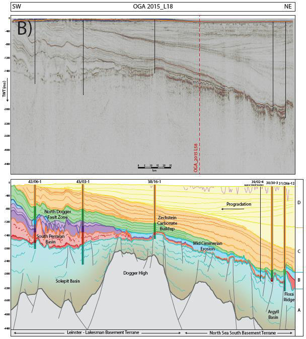
Utilising the Oil and Gas Authority's 2D Government seismic data in the frontier areas of the Mid North Sea High, Rockall Trough and SW Approaches, Heriot-Watt's contribution was funded through the OGA's Frontier Basin Research post-doctoral projects.
Professor John Underhill, Heriot-Watt's Chair of Exploration Geoscience and Dr Rachel Jamieson co-led the two-year PDRA project studying the Mid North Sea High area. Dr Rachel Brackenridge, Postdoctoral Research Associate, undertook the interpretations.
Professor Underhill said: “This was the first time that the UK Regulator contracted academic institutes to undertake subsurface mapping of this type. It is excellent to hear about the added value and significant impact the research project outcomes have had for Government and industry alike.”
The final set of geological maps to be completed cover the West of Shetlands, Rockall Trough, Irish Sea and cardigan Bay and have now been released. Produced by Lloyd's Register, a single merged set of maps and databases for the entire UK continental shelf is now available providing high quality digital, updatable, regional geological maps and associated databases.
Third party data sources used include UK data from CGG, TGS, PGS and the British Geological Survey with cross-border data provided by Petroleum Affairs Division, Ireland, the Netherlands Organisation for Applied Scientific Research and Jardfeingi (Faroese Geological Survey). The University of Aberdeen and Durham University were also academic collaborators.
To view the maps, click here.